City Guide
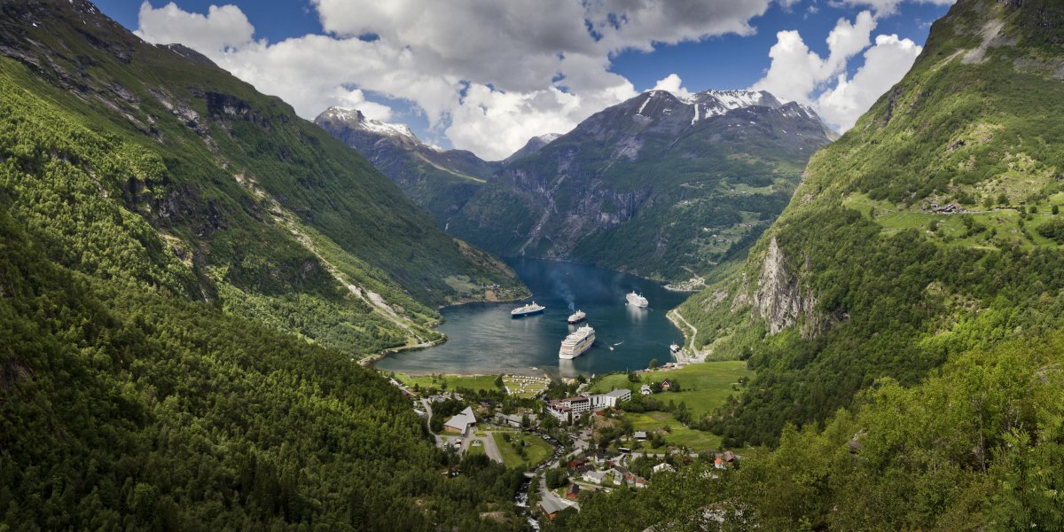
Lofoten Islands
Noruega · Best time to visit: Jun-Aug midnight sun; Feb-Mar Northern Lights.
Day-by-day plan
Choose your pace
Duración del viaje
07:30
Landmark
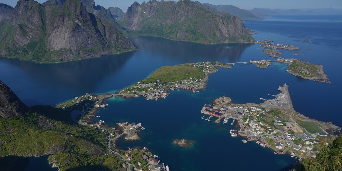
Start at the trailhead just south of Hamnøy where 1,978 Sherpa-built stone steps zigzag straight up the mountain — there is no warm-up, the climb begins the moment you leave the car park. By 09:30 the sun crests Olstinden and pours into Reinefjorden below, turning the water electric blue while the red rorbu of Hamnøy float far beneath you like toy boats. The 448 m viewing platform delivers the single most photographed panorama in Norway — earn it now before the mid-morning queue forms on the upper steel-cabled sections.
Tip: Be on the steps by 07:30 — by 11:00 you'll spend an extra hour stuck behind slow descenders on the cabled upper traverse. Wear grippy trail shoes (trainers slide on wet stone) and bring micro-spikes in April–May for residual ice. Park inside the marked Reinebringen lot under the road tunnel, not the roadside pull-offs which get ticketed.
Open in Google Maps →10:45
Neighborhood
Descend the Sherpa Steps back to E10 and walk north 1.5 km along the road shoulder, crossing two arched red bridges over a fjord narrows with the granite spire of Festhælen looming straight ahead. Stop at the small pedestrian footpath on the south side of the second bridge — this exact spot is the angle every Lofoten poster is shot from, with the Eliassen Rorbuer cluster appearing to float on the water beneath the mountain. At this hour the sun is still low enough to backlight the peak dramatically, well before the noon tour buses arrive.
Tip: The iconic shot is from the south footpath of the second bridge, NOT the layby on the north side where tour buses pile up — frame the foreground rocks low and let Festhælen dominate the upper two-thirds. The rorbu walkways are private accommodation: do not step onto the wooden decks or peer through windows, locals have started fencing off offenders after a wave of Instagram trespassing.
Open in Google Maps →12:00
Food
Walk south 1 km back across the bridges to the cluster of yellow rorbu at Sakrisøy — Anita's wooden cabin sits on your right, perched directly over the fjord. Anita Maurstad runs the most legendary food stop in Lofoten from this converted fisherman's hut: order the fiskeburger (195 NOK / €17), a hand-formed cod patty in a brioche bun that is far better than it has any right to be, plus one of her warm cinnamon buns (60 NOK / €5). Eat at the wooden picnic benches outside with Olstinden's perfect pyramid filling the entire horizon.
Tip: Arrive by 11:55 or after 14:00 — between 12:30 and 13:30 the line spills into the parking lot and waits hit 40 minutes. Cinnamon buns sell out by 14:00 sharp. Skip the smoked salmon platter (overpriced for the portion); the fiskeburger and a bun is the locals' order, eaten standing up if the benches are full.
Open in Google Maps →13:30
Neighborhood
Walk south on E10 for 2 km, passing the small white Moskenes church and one final low bridge before the painted harbor of Reine opens to your left. Wander the wooden boardwalk that loops the harbor past the red rorbu, the hjell drying racks, and the cemetery — at mid-afternoon the katabatic wind dies down and the harbor surface goes mirror-still, giving you the perfect reflection of Olstinden's pyramidal peak. Continue out to the rocky tip of the small peninsula past the cemetery for the village's best inward view, with seven jagged summits stacked behind the red roofs.
Tip: Skip the 'I ❤️ Reine' photo sign by the parking lot — it's a recent install with a constant queue and no view. The peninsula-tip angle (10 min walk past the church) is what serious photographers come for: village in foreground, seven peaks behind, no fences, no cables. Public toilets are inside the harbor information building, not the rorbu camps which are guests-only.
Open in Google Maps →16:00
Neighborhood
Catch the local Reis Nordland bus from Reine harbor 10 km south to Å (15 min, ~70 NOK) — the road threads cliffs above the open Atlantic and is itself part of the experience. Å is literally the end of the road: the E10 highway terminates at this 19th-century stockfish village whose 17 black-tarred wooden buildings are preserved as a working museum complex. Walk through the cluster of boathouses, past the old cod liver oil factory, and out to the tiny harbor where the open Norwegian Sea begins — overhead, the constant clatter of cod racks (tørrfisk) is the soundtrack of a thousand-year trade.
Tip: Walk past the museum buildings to the small unmarked headland behind the village (10 min on a rough path through rocks) — there is a viewpoint over the southern islands and open Atlantic with zero other visitors. Pitfall warning: avoid the cafés at the main Å parking lot — they charge €9 for instant coffee and microwaved waffles, and the operator there is unrelated to the historic Bakeriet i Å inside the museum proper, which is the real one and closes at 17:00.
Open in Google Maps →19:00
Food
Walk back north along E10 for 3 km from Å to Sørvågen as the low evening sun bronzes the fjord — the white wooden inn sits directly above the small harbor on your left. Maren Anna has been Sørvågen's restaurant since the late 1800s and is the most consistent serious dinner south of Svolvær: order the bacalao (cod stew with potatoes, olives, tomato; 285 NOK / €26) or the daily catch grilled simply with brown butter (~400 NOK / €36). The dining room is upstairs with picture windows over the harbor; in summer the midnight sun lights your meal past 23:00.
Tip: Reserve via their website 24+ hours ahead — there are only 30 covers and walk-ins after 19:00 are turned away in summer. Ask for a window table on the harbor (north) side. If it's August or September, ask whether they have moltebær (cloudberries) with cream off-menu from local pickers — it is the one true Lofoten dessert. Pitfall warning: do NOT eat at the parking-lot fish kiosks along E10 between Reine and Å — they charge €20 for reheated frozen fish soup aimed at cruise day-trippers; the only honest food on this stretch is at Anita's, Maren Anna, or the Å museum bakery.
Open in Google Maps →Saltar al día
06:00
Landmark
Park at the small lay-by 200 m past the Reine tunnel exit on the E10 — the wooden trailhead sign is right there. 1,978 Nepali-Sherpa-built stone steps climb 448 m to a knife-edge ridge with the entire Reinefjord splayed below: red rorbu, jade water, jagged peaks. At dawn the sun rises behind you and pours sideways into the fjord, turning the cabins copper for about twenty minutes.
Tip: Start at 6 a.m. — by 9 the steps become a single-file queue and the top platform fills with tripods. Bring trekking poles for the descent; the steps are slick when dewy. Skip the unofficial scramble past the railing — three rescue calls a year happen up there.
Open in Google Maps →11:00
Landmark
Drive 4 minutes east on the E10 and pull into the tiny gravel lot just before Hamnøy bridge — you'll see photographers already there. This is the single most photographed scene in Norway: clustered red fishermen's cabins on stilts, Festhælltinden's serrated tooth rising behind them. Late morning the sun has just cleared the ridge, so the cabins glow without the harsh shadow you get at midday.
Tip: Walk onto the smaller second bridge (north side) — not the bigger E10 bridge. From there the cabins wrap around the mountain instead of lining up flat. Bring a wide angle; 24 mm equivalent nails the composition without distortion.
Open in Google Maps →12:30
Food
Drive 5 minutes back east on the E10 to the bright yellow building on Sakrisøy island — you literally cannot miss it. Anita Måland cures her own stockfish behind the deli counter and serves the legendary Sakrisøy fish burger (195 NOK) and a salmon-and-cod burger (210 NOK) on her grandmother's bread. Take it outside to the wooden bench facing Olstinden mountain; this is where fishermen actually eat lunch.
Tip: Order at the deli counter, not the café tables — same food, half the wait. Add a small jar of her cloudberry jam (95 NOK) for the rorbu breakfast tomorrow. Skip the smoked-whale tasting board; Norwegians don't eat it, and it's there for cruise passengers.
Open in Google Maps →14:30
Neighborhood
Drive 12 minutes south on the E10 — the road simply ends here, at the village called Å (literally 'river' in Old Norse). Eleven preserved 19th-century buildings cluster around a stone harbor: the cod-liver oil refinery, the boathouse, the 1844 bakery, the Norwegian Fishing Village Museum. Afternoon light slants low between the buildings and makes the tarred wood smell like creosote and salt.
Tip: Walk straight to the bakery first — they bake cinnamon rolls (50 NOK) in the original 1844 wood-fired oven and stop at 16:00 sharp. The museum's cod-liver oil shed is the most photographed interior in Lofoten; aim a wide lens at the rows of brass lamps.
Open in Google Maps →17:00
Neighborhood
Drive 10 minutes back north on the E10 and park near Reine church — the harbor stroll begins behind it. Loop the rorbu-lined wharf clockwise; at this hour the sun drops behind Olstinden and turns every red cabin into burning ember against navy water. End at the small wooden footbridge behind the school — a local shortcut that almost no tourist finds, and the best private angle on the village.
Tip: The footbridge sits on the west side of the church — look for a narrow gravel path between two private rorbu fences. Locals use it; just stay on the path and don't lean on the cabin railings.
Open in Google Maps →19:30
Food
Walk 4 minutes along the harbor from the footbridge to Reine Rorbuer hotel — Gammelbua occupies the 1864 trading post, original beams blackened by 160 years of cod-liver smoke. The bacalao (395 NOK), made with stockfish dried in Lofoten's own racks, is what every Norwegian chef orders here. Pair it with the reindeer fillet from Vesterålen (495 NOK) and the house aquavit flight.
Tip: Reserve at least 3 days ahead in summer; ask specifically for a window table on the harbor side. Pitfall: ignore the 'authentic local fish soup' boat tours hawked at Reine harbor — they're frozen-stock buffets at triple the price. Also skip the 'Lofoten viking dinner' Facebook ads in Moskenes; it's a costumed theme show, not food.
Open in Google Maps →09:00
Park
From Reine, drive 75 minutes northeast on the E10 — the road itself is the sight, so budget pull-overs at Flakstad church and Ramberg. Haukland is an Arctic-Caribbean impossibility: bone-white sand, glacial-turquoise water, the 564 m wedge of Mannen rising straight from the dunes. Morning light hits the beach from the southeast at the perfect grazing angle for the postcard panorama.
Tip: Walk 15 minutes up the marked Mannen ridge trail from the parking lot's north corner — you only need to climb to the first shoulder (about 100 m elevation) for the iconic looking-down shot. Avoid the official Mannen summit unless you have 2.5 hours; the upper ridge is exposed and far steeper than it looks from below.
Open in Google Maps →11:30
Neighborhood
Drive 35 minutes east; turn off the E10 at the signed Henningsvær spur and cross the two arching bridges onto the island cluster. The village is white-painted timber houses balanced on bare granite skerries, fishing boats nose-in everywhere, and the famous emerald-green football pitch (Henningsvær Idrettslag) tucked on Hellandsøya. Locals call this 'the Venice of Lofoten' — it really is built on rock islets connected by bridges.
Tip: For the viral drone-style view of the football field, climb 35 minutes up Festvågtind — the trailhead is on the right just before the second bridge into the village. The summit is only 541 m but gives you the entire archipelago at your feet. Even without a drone, this is the best non-aerial angle that exists.
Open in Google Maps →13:00
Food
Walk 6 minutes from the football field bridge into the village center — Klatrekafeen sits above the old sail loft next to Nord Norsk Klatreskole. This is a working climbers' café: ropes coiled in the entry, climbing photos floor to ceiling, and the cinnamon bun (kanelbolle, 65 NOK) widely accepted as the best in Lofoten. Pair with the daily fish soup (215 NOK), thick with cod and king crab off the morning boat.
Tip: Sit upstairs by the window with the climbers' photo wall — quieter and the light is better for photos. Order the cinnamon bun first; they sell out by 14:00 and don't bake a second batch. Cash and card both work, but tipping isn't expected — locals don't.
Open in Google Maps →15:00
Entertainment
Drive 25 minutes east on the E10 to Svolvær harbor and board at the central pier — XXLofoten's orange RIB boats are docked at the inner basin. The boat tears across Vestfjorden into a slot canyon barely 100 m wide between vertical 1,000 m walls: that's Trollfjord. White-tailed sea eagles ride the thermals overhead, the captain cuts the engine in the silence at the head, and waterfalls fall straight onto the deck.
Tip: Book the smaller XXLofoten RIB, not the big Brim catamaran — RIBs squeeze into the narrow inner channel where catamarans literally cannot fit. Wear the provided floatation suit over a fleece; even in July the wind chill at 35 knots is brutal. Sit on the right (starboard) side outbound for the cliff face.
Open in Google Maps →18:30
Museum
Walk 4 minutes from the harbor pier to the Town Hall square — the museum occupies a corner of the 1930s civic building. Owner William Hakvaag has assembled one of Europe's most personal WWII Resistance collections: original SS uniforms, the Lofoten Raid documents, Norwegian Heroes' Cross medals. Evening is the right time — the room is dim, you're alone with the artifacts, and the curator himself is usually there to talk.
Tip: Ask William directly about the painting attributed to Adolf Hitler in case 14 — he'll tell you the whole authentication story. The museum is small and dense; 45–60 minutes is plenty. Closed Sundays in shoulder season, open daily late June through August.
Open in Google Maps →20:00
Food
Walk 4 minutes back toward the harbor — Børsen sits on the old Svinøya trading wharf, its dining room literally cantilevered over the water on creosoted pilings from 1828. The stockfish in white sauce (435 NOK) is made from cod the owners' family dries 30 m from your table; the reindeer carpaccio (255 NOK) comes from a Sami herder in Vesterålen. Finish with the multebær (cloudberry) panna cotta and a Linie aquavit.
Tip: Reserve at least 4 days ahead in summer; ask for the corner table on the wharf side — you'll watch eider ducks under the floorboards through the gaps. Pitfall: skip the chain seafood restaurants on Svolvær's main harbor square (Bacalao Café Bar, Du Verden) — they're tourist-priced and frozen-sourced. Børsen is where Lofoten's other chefs eat on their nights off. Also ignore street touts selling 'Northern Lights tours' in July — there are none, the sky never gets dark.
Open in Google Maps →Saltar al día
08:00
Landmark
From Reine village it is an 8-minute walk south along the E10 to the trailhead at the tunnel entrance, where 1972 Sherpa-built stone steps climb 448m straight up the fjord wall in under an hour. At the summit the entire western archipelago unfolds — Reine, Sakrisøy, Hamnøy, and the granite teeth of Olstinden mirrored in still water. Stay 30 minutes; as the light shifts across the rorbu villages below, this becomes the photograph you keep forever.
Tip: By 10:30 the staircase is a queue of tour groups; 8 a.m. is the hour. Check Yr.no the night before — if cloud base is under 400m the summit will be locked in fog and you will see nothing, so save it for the next clear morning.
Open in Google Maps →11:00
Landmark
Drive 8 minutes north on the E10, park at the Eliassen Rorbuer lot, and walk to the second small bridge linking Hamnøy to Sakrisøy. This is the most photographed angle in Norway — clusters of crimson rorbu nestled beneath the snow-flecked spine of Festhæltinden, doubled in the fjord. By late morning the sun has cleared the southern peaks and lights the cabins directly; fishing boats glide back into the harbor with the morning catch.
Tip: The postcard view is from the SECOND bridge looking northwest, not the first one beside the parking lot. Stand on the grass shoulder, never the bridge itself — cars on E10 come fast and don't slow for photographers.
Open in Google Maps →12:30
Food
Four-minute walk west across the bridge onto Sakrisøy, past the row of mustard-yellow rorbu, to where Anita Sand has run this fish counter for two decades. The fiskeburger (€15) is the signature — cod minced fresh that morning, lightly fried, served on a soft bun with house remoulade. Take a window seat looking across to Olstinden; this is the lunch the people of Reine drive here for.
Tip: Order the smoked-fish tasting plate (€16) to share before the burger — Anita smokes her own salmon and stockfish on site. No reservations; arrive by 12:30 to claim a window seat before the bus tour wave at 13:00.
Open in Google Maps →14:30
Museum
Drive 12 minutes west on E10 to the literal end of the road — the village of Å (one letter) has 100 residents and Norway's most complete preserved 1800s fishing settlement. Wander through the cod-liver-oil factory, the cooper's workshop, and the rorbu kitchen still laid for a family of fishermen returning from sea. Stop at the working bakery for a cinnamon roll baked from an 1844 recipe in the original brick oven.
Tip: The drying racks (hjell) at the village edge are most photogenic between 15:00 and 16:00 when low afternoon sun rakes across the cod skeletons. The bakery sells out of cinnamon rolls by 16:00 — buy yours before exploring the museum proper, not after.
Open in Google Maps →19:00
Food
Drive 15 minutes back east to Reine, where Gammelbua sits in a 200-year-old waterfront warehouse jutting over Reinefjord. Order the bacalao Lofoten-style (€38) or the cod-tongue starter (€18) — the kitchen sources everything from boats moored 50 meters from the dining room. In summer the long evening light pours through the small-paned windows past 22:00; reservations are essential.
Tip: PITFALL — skip the cruise-tourist cafés along the E10 between Reine and Sørvågen; their fish is frozen and prices double. Anywhere with menu boards in five languages or photos of the dishes outside the door is for tour buses, not locals.
Open in Google Maps →10:00
Landmark
Drive 30 minutes northeast from Reine on E10, then turn south on FV807 to the harbor cul-de-sac of Nusfjord — one of Norway's few still-working 1800s fishing settlements and a UNESCO Pilot Project site. Walk the wooden boardwalks past the cooper's shop, the smithy, and the old cod-liver-oil factory; everything is still in working use, not staged for display. Climb the unmarked footpath behind the red Krambua building (15 min) to the bench above the harbor for the aerial view most day-trippers miss.
Tip: The park-and-explore fee is €9 at the entrance — pay it without arguing; it funds village restoration. The Svolvær day-tripper ferries don't arrive until noon, so the boardwalks are entirely yours before lunch.
Open in Google Maps →12:30
Food
Five-minute walk back along Nusfjord's boardwalk to the restored factor's house overlooking the harbor mouth. The fish soup (€18) is made fresh each morning from the catch landed below; the bacalao Lofoten-style (€28) and the slow-braised local lamb shank both come from one farm 6 km away. Strong black coffee arrives in enamel campfire mugs while gulls cry over the open window.
Tip: Book a harbor-window table by phone one day ahead; inside tables are pleasant but lose the view that makes the meal. Ask for the torsketunger (cod tongues) outside of lutefisk season — they're a Lofoten specialty almost no tourist orders.
Open in Google Maps →15:00
Park
Drive 40 minutes northeast on E10 to Vestvågøy's western coast. Haukland's caribbean-white sand bay sits beneath the dark wall of Veggen; walk over the small ridge of Mannen on the cairned trail (15 min) to neighboring Uttakleiv Beach on the other side, where rounded boulders and the famous heart-shaped rock formation face a wilder surf. Afternoon north-facing light bathes both beaches between 14:00 and 17:00 and the wind drops to its calmest.
Tip: The 15-minute ridge path between the two beaches is the best part — most visitors stop at only one. Park free at the marked Haukland lot, never on the unsigned roadside pullouts which are private farmland and earn you a fine.
Open in Google Maps →17:00
Park
Drive 15 minutes west on the narrow FV835 over a small mountain pass — the descent into Unstad's crescent bay is one of Norway's great driving moments. Watch the Arctic surfers in their black wetsuits ride the breaks at the world's northernmost surf school, or walk the cliff trail 20 minutes north to the small Unstad lighthouse for the wide view back across the bay. Late afternoon golden light lands on the surf at exactly this hour.
Tip: Stop at the Unstad Arctic Surf café for the village waffle (€9) — heart-shaped, served with brown cheese (brunost) and cloudberry jam, the way locals eat it. The lighthouse trail is unsigned; look for the small parking pullout 200m past the surf school on your right.
Open in Google Maps →19:30
Food
Drive 25 minutes south to Ballstad — Hattvika's restaurant occupies a rebuilt cod-liver-oil factory directly over the water of the small fishing harbor. The chef cooks one set four-course menu (€68) using only Vestvågøy ingredients: lamb from the slopes above the lodge, halibut from the boats outside the window, cloudberries from the bog up the road. The room hums with returning fishermen and in-the-know travelers.
Tip: PITFALL — the larger Leknes restaurants along E10 with multilingual sandwich boards out front are built for the cruise-ship lunch trade; their prices run 30% above what locals pay for the same fish. Reserve Hattvika two days ahead in summer; one day ahead is too late.
Open in Google Maps →10:00
Museum
Drive 30 minutes northeast from Leknes on E10 to Borg, where the largest Viking longhouse ever excavated (83m) has been faithfully reconstructed on its original footprint. Inside the great hall, blacksmiths work iron at the forge, the chieftain's high seat looms at the head of the feast bench, and the air smells of woodsmoke from open hearths. Walk down to the lake afterwards for the reconstructed Viking longship Lofotr moored at the dock.
Tip: Sit at the head of the chieftain's feast table and look straight up at the smoke hole — that's the best photograph in the museum and almost no visitor takes it because everyone queues for the costume room. Be at the doors at 09:55; the tour-bus groups arrive at 10:30.
Open in Google Maps →13:00
Food
Drive 35 minutes northeast on E10, then south over the bridges to the island cluster of Henningsvær, where Fiskekrogen sits directly on the inner harbor. King Harald V has eaten here; the fish soup (€22) — eight kinds of seafood in a saffron-cream broth — is the dish to order. Pair it with cod-cheek mølje (€38), the traditional fisherman's lunch of poached cod with liver and roe.
Tip: Reserve a window table 24 hours ahead — the inner tables face the kitchen pass and lose the harbor view that makes the meal. Skip the tourist-marked seafood platters; order what the locals do: soup first, then mølje.
Open in Google Maps →15:00
Neighborhood
Two minutes' walk from the restaurant into Henningsvær's island-cluster center, threaded by short stone bridges. Walk to the famous football pitch on the southern islet — at ground level the bay frames the goalposts perfectly — then duck into Galleri Lofotens Hus, where painter Karl Erik Harr's lifetime of Lofoten light hangs in a converted fishhouse. Slowly rotating spotlights in the dim main room mimic polar dusk and dawn moving across his canvases.
Tip: For the aerial football-pitch perspective everyone has seen online, hike 15 minutes up the unmarked path on Lillehagen hill at the north end of the field. The Red Bull shot was a drone, but the human-eye version from up there is nearly as good and entirely free.
Open in Google Maps →17:30
Neighborhood
Drive 25 minutes east on E10 to Svolvær and cross the bridge to Svinøya — the original fishing settlement, now a rorbu hotel district but still working at its edges. Walk the wooden plank paths between red cabins, then continue to the stockfish racks at the far end where cod has hung curing in the wind since February. Look up: the granite goat-horns of Svolværgeita catch the last evening sun above town.
Tip: Touch one of the hanging cod on the racks — it's stiff as carved wood after three months in the Lofoten wind. The plank paths around the racks are public; stay quiet at the back warehouses where fishermen still work past 18:00 and you'll see something tour buses never reach.
Open in Google Maps →19:30
Food
Three-minute walk along the Svinøya boardwalk to Børsen — an 1828 fishermen's warehouse converted into Lofoten's oldest restaurant, wooden floors creaking, walls hung with coiled rope and old harpoon heads. The four-course Lofoten Table (€70) presents stockfish in three preparations including the legendary lutefisk in season. This is where locals book a special occasion, not where tour groups land.
Tip: PITFALL — the pub cluster around Svolvær's Torget harbor square charges tourist prices for indifferent fish; locals walk past these and over the bridge to Svinøya. Ask for table 3 by the rear window — the one with the original 1828 floorboards visible underneath your feet.
Open in Google Maps →
Trip builder
Plan this trip around Lofoten Islands
Turn this guide into a bookable rail itinerary with FlipEarth.
Keep exploring
Related cities
More in the same country
FAQ
Frequently asked questions
How many days do you need in Lofoten Islands?
Most travelers enjoy Lofoten Islands in 1 days, with enough time for headline sights and a slower meal or museum stop.
What's the best time to visit Lofoten Islands?
The easiest season for most travelers is Jun-Aug midnight sun; Feb-Mar Northern Lights, especially if you want good weather and manageable crowds.
What's the daily budget for Lofoten Islands?
A practical starting point is about €180 per person per day before hotels, then adjust based on museums, dining, and transport.
What are the must-see attractions in Lofoten Islands?
A good first shortlist for Lofoten Islands includes Reinebringen Sherpa Trail.