City Guide
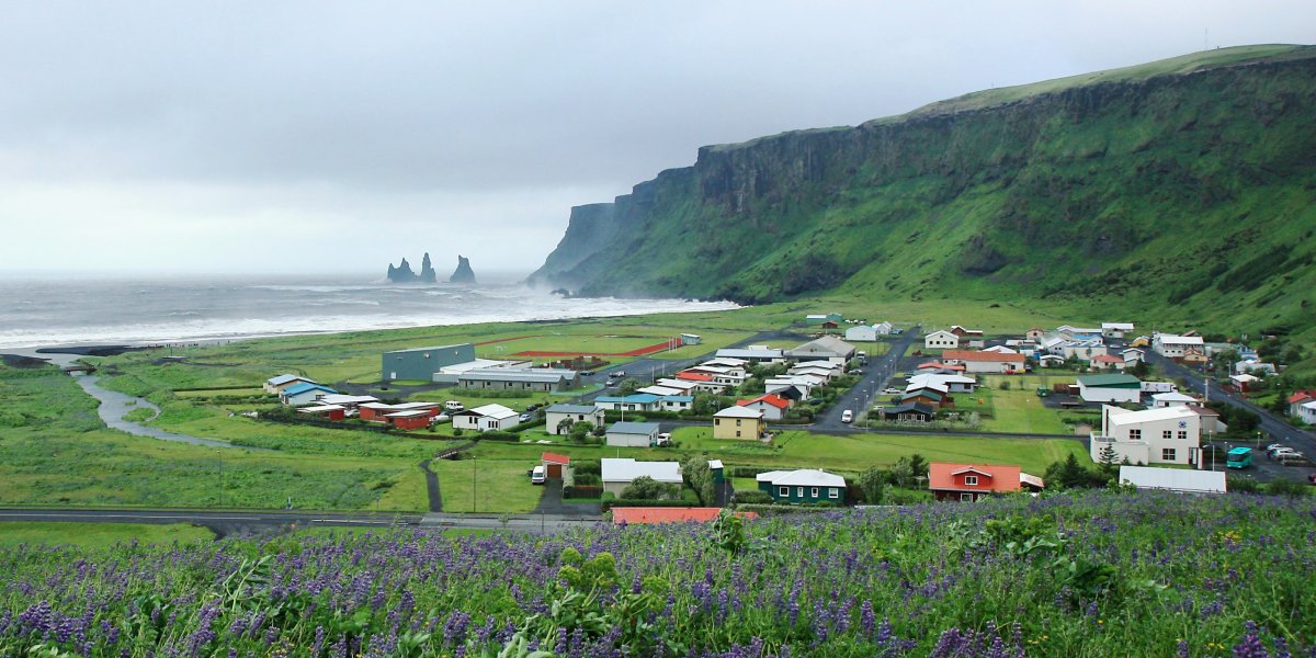
Vik i Myrdal
Islande · Best time to visit: Jun-Aug.
Day-by-day plan
Choose your pace
Durée du voyage
08:30
Landmark
Pull off Route 1 at the brown Skogafoss sign — the falls reveal themselves before you cut the engine, and a flat gravel path leads you straight toward the spray in five minutes. Sixty metres of glacial water drop over a sheer cliff that was the Atlantic shoreline ten thousand years ago, when the sea reached this far inland. Climb the 527 steel steps on the right for a top-down view that strips the cataract down to pure geometry; come down on the same staircase and walk the lower platform last so you finish wet, awake, and committed to the day.
Tip: Wear waterproofs, not a poncho — the wind funneling down the gorge flips ponchos inside-out within seconds. The morning rainbow sits strongest on the lower platform between 08:30 and 10:00 while the sun is still low in the south-east; after 11:00 the angle flattens and the bow vanishes, which is also when the Reykjavik tour buses unload.
Open in Google Maps →11:00
Landmark
Thirty-minute drive east on Route 1, then south on Route 215 until the tarmac dies at the beach car park; from the lot it is a two-minute walk past the red warning sign and over a low dune before the basalt cliff opens on your left. Hexagonal columns stack like a colossal pipe organ at the foot of Mount Reynisfjall, and out in the surf the three Reynisdrangar sea stacks rise blackly from the water — petrified trolls, the old farmers say, caught above ground by sunrise. Walk left toward the Halsanefshellir cave for the cleanest column geometry, then turn 180 degrees and frame the stacks against open ocean — the next landfall south is Antarctica.
Tip: Never turn your back on the water — Reynisfjara's sneaker waves have killed tourists who stepped down to the wet sand for a photo, and they arrive without warning every few minutes. Stay above the darker wet line at all times. The basalt columns photograph cleanest between 10:30 and 12:00 when the sun is overhead and stops throwing heavy shadow into the cave mouth.
Open in Google Maps →12:30
Food
Two minutes back from the cave the angular black-clad cabin sits right at the cliff base — same car park as the beach, with floor-to-ceiling glass framing the surf for everyone who got a window seat. A glass-walled cafeteria built into the basalt by a local family who have fished these waters for generations. Order the langoustine soup (ISK 3,200 / approx EUR 22) — sweet shellfish broth thick with cream and served with warm sourdough — or the slow-cooked Icelandic lamb stew (ISK 2,900 / approx EUR 20). Eat fast, eat with the Atlantic in your peripheral vision, and you have done lunch the way locals do it.
Tip: The counter queue moves quickly but the window tables fill by 12:45 when the Reykjavik day-tour buses arrive — grab a window seat the second you walk in, then send one person to order. Skip the EUR 12 hot dog; the soup is the only thing islanders actually order here, and the bread refill is free.
Open in Google Maps →14:00
Landmark
Fifteen-minute drive back west along Route 218; the gravel road climbs sharply for the last kilometre to the upper car park by the orange lighthouse, and from the lot it is a three-minute walk along the cliff edge to the arch overlook. A 120-metre basalt headland punched through by a sea arch tall enough to fly a small plane under — the name means door-hill, and pilots have done it on a dare. The upper plateau gives you the day's grandest sweep: east across Reynisfjara to the troll-stack silhouettes, west to a curved black beach that runs unbroken for twenty kilometres. From mid-May to mid-August puffins nest in the cliff burrows immediately below the path; they let you within two metres if you sit and stay still.
Tip: Walk to the lighthouse first then double back to the eastern cliff edge — the iconic framing of the arch with the Reynisdrangar stacks behind it only composes from that side, and most visitors miss it because they leave from the lighthouse car park. The lower car park (Haey) closes from 19:00 to 09:00 during puffin nesting season; the upper one stays open year-round.
Open in Google Maps →17:00
Religious
Twenty-minute drive east back to Vik village; park along Vikurbraut and climb the steep grass path that cuts up behind the village houses — five minutes up, the calves burn, the view is the reward. A simple white timber church with a blood-red roof, sitting alone on the only hill above town and built deliberately as the village's evacuation point should the Katla volcano beneath Myrdalsjokull ever erupt and unleash a glacial flood — every villager has been told that if the siren sounds, run uphill to the church. From the steps the entire village curves below you, the black beach stretches eastward toward the horizon, and the three Reynisdrangar rise from the surf as the late sun drops behind Dyrholaey on your right.
Tip: Golden hour in Iceland's summer drags from 21:00 to 22:30, but the classic church-and-stacks composition shoots cleanest between 17:30 and 18:30 when the light is still angled but warm and the church roof glows against the dark mountain behind. Avoid the wool-sweater shops along Vikurbraut on the way down — they are mass-produced in Asia and priced double the Reykjavik handknitter rate; the only authentic lopapeysa in town is at the Icewear factory shop opposite the petrol station.
Open in Google Maps →19:30
Food
Walk down the church hill, cross Vikurbraut, and the brown timber cottage with white window frames is two minutes south on your left. A 1930s house converted into the village's proper sit-down restaurant by the Hannesson family — twelve tables, candles, wood-panelled walls hung with old fishing photographs. Order the Icelandic lamb fillet (ISK 5,900 / approx EUR 40) — local Myrdalur lamb that grazes on wild thyme, served with a juniper-berry jus — or the pan-fried Arctic char (ISK 4,800 / approx EUR 33) pulled from the rivers thirty kilometres north. The skyr cheesecake with wild crowberries is the dessert that has never disappointed anyone at this table.
Tip: Reserve before 18:00 by phoning +354 487-1515 — only twelve tables, and summer walk-ins after 19:30 routinely wait an hour outside in the wind. Ask for a window table on the right side as you enter; the left side faces the kitchen pass and loses the view of the church on the hill.
Open in Google Maps →
Trip builder
Plan this trip around Vik i Myrdal
Turn this guide into a bookable rail itinerary with FlipEarth.
Keep exploring
Related cities
More in the same country
FAQ
Frequently asked questions
How many days do you need in Vik i Myrdal?
Most travelers enjoy Vik i Myrdal in 1 days, with enough time for headline sights and a slower meal or museum stop.
What's the best time to visit Vik i Myrdal?
The easiest season for most travelers is Jun-Aug, especially if you want good weather and manageable crowds.
What's the daily budget for Vik i Myrdal?
A practical starting point is about €180 per person per day before hotels, then adjust based on museums, dining, and transport.
What are the must-see attractions in Vik i Myrdal?
A good first shortlist for Vik i Myrdal includes Skogafoss Waterfall, Reynisfjara Black Sand Beach, Dyrholaey Promontory.